The Coastal Fynbos Trail - Port Elizabeth
- Port Elizabeth
The Coastal Fynbos Trail
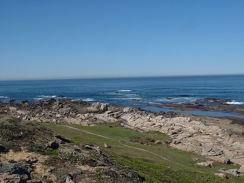
This circular trail of about 7 km starts at Sappershoek which is at the eastern end of the seaside village of Schoemakerskop. An inland route makes its way through the coastal fynbos as far as a cellphone tower, returning to Sappershoek along the top of a ridge overlooking the sea.
The area between Schoenmakerskop and Summerstrand is known as Driftsands after the shifting by-pass sand dune system that used to cover the area. The sands were stabilised at the beginning of the 1900's. Australian wattles such as Rooikrans and Port Jackson Willow were planted as well as Eucalyptus trees in an attempt to start a commercial forest. Low rainfall (approx 600 mm per year), poor soil and strong salt-laden winds were not conducive to tree growth and the trees were never harvested commercially. This alien vegetation invaded large areas, preventing indigenous vegetation from growing. Much of the alien vegetation has now been cleared from the trail area, allowing the indigenous plants to re-establish themselves.
The underlying rock here is Table Mountain Sandstone. This supports fynbos and is found only between Port Elizabeth and Cape Town. Fynbos is the smallest, most diverse and most endangered of the world's six floral kingdoms, supporting approximately 9,000 plant species of which 70% are endemic. Along the trail calcrete outcrops, derived from Calcium rich marine deposits and deep dune sands, together with variations in topography and the influence of salt-laden winds and fire, have led to a mosaic of vegetation communities.
It is worth noting that after huge fires in January 1998 the area resembled a desert. The vegetation has since recovered and the area is dominated by asteraceous fynbos. In places that the fire missed the fynbos/coastal dune thicket is much taller and the fynbos is dominated by metalasia and agathosma (buchu). Orchids such as Eucormis and Sayirium are a common sight in spring. Without fire the coastal dune thicket, comprising many first species, would become more dominant.
On the trail look out for Thysbe's Copper butterfly whose range reaches its easternmost limit here. In flight it has a blue hue but at rest appears orange. Small grey and yellow mongoose may be seen as well as Cape Grysbok. Keep a lookout to seawards for whales. Southern Right Whales are present mainly between August and early October while Humpbacks migrate along this stretch of coast between April and early December and can provide spectacular viewing.
Please note that use of the area is at your own risk.
Map and Directions to The Coastal Fynbos Trail
GPS : 34° 2' 31.77" S / 25° 33' 15.09" E
From the central or seaside parts of the city
Continue on Marine Drive right through the Cape Receife Nature Reserve until you reach Sappershoek (clearly signed). The trail starts about 100m inland from Marine Drive at the north-west corner of Sappershoek.
From the west
From Buffelsfontein Road turn into Victoria Drive, next to Walmer location and follow this to the sea. Turn left into Marine Drive, drive about 700m and the starts about 100m inland from Marine Drive at the north-west corner of Sappershoek.