Bartholomeu Dias Museum - Mossel Bay
- Mossel Bay
Bartholomeu Dias Museum
Bartholomeu Dias
King João (John) II of Portugal, inspired by his great uncle, Prince Henry the Navigator, was determined to find a sea route to India via the southern tip of Africa.
In 1482 he sent Diago Cão with two ships to survey and chart the west coast of Africa. Cão, on his first and second voyages paved the way for Bartolomeu Dias, who left Lisbon in August 1487 with two caravels of 100 tons each, and a bigger store ship.
Dias sailed along the coast of Africa as far South as a harbor later known as Baia dos Tigres. He passed Cão's last padrão at Cape Cross. With the northern Cedarberg in sight, Dias probably grew tired of tacking against a stormy southern wind, and sailed out into the open sea.
Thus he sailed round the southern tip of Africa without realizing it. It was when he steered eastward and could not find any land that he took a northerly course, thereby seeing land again at the Gouritz River or Rio dos Vaquerios.
Here the waves prevented him from landing, but on the festival day of Saint Blaize he managed to do so further on in a protected cove which he named "Aguada de São Bras" (watering place of Saint Blaize) because of the freshwater spring he found there. This was later renamed Mossel Bay by the Dutch. For several years after this the Portuguese touched at São Bras to take on fresh water and meat.
In the mid 17th Century the Dutch East India Company decided to set up a refreshment station at the Cape, and it was yet another hundred years before any settlement at Mossel Bay itself was planned.
Of the five National Monuments on the museum grounds, 4 are buildings dating between 1830 and 1902. The museum grounds themselves situated on the shores of the Indian Ocean are a magnificent historical setting.
They are situated at the very site where European explorers came ashore and made contact with the indigenous people. Information about the Khoi-Khoi and explorers can be seen in the Maritime museum.
The Granary
The Granary was built in 1786 by the Dutch East India Company. This led to the opening up and expansion of the grain and wool trades. In 1949/50 a large warehouse was erected on the site by the “Suid Westelike Landbou Bpk.” And the 1787 granary was demolished. With the demolition of the warehouse in 1986 the original foundations of the granary were discovered and a replica of the 1786 building was then erected on them.
It is now used as a the main entrance for the museum complex and educational centre.
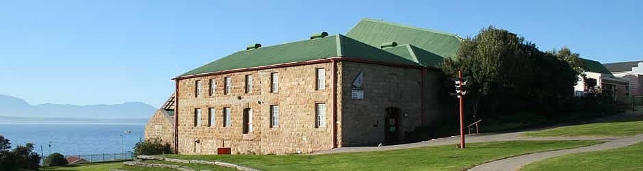
The Maritime Museum
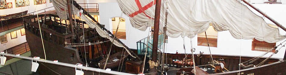
The building as originally erected in 1901 to serve as a grain and sawmill. It has now been adapted to serve as a unique Maritime Museum. A life-sized replica of Bartolomeu Dias’s caravel is on display together with all aspects of the maritime history of the early Portuguese, Dutch and English navigators. Among the many particular exhibits are :
- Bartholomeu Dias
- Vasco da Gama
- The Overland Trade Route
- Portuguese Exploration
- Shipwrecks
The museum also holds a life-size replica of Dias' caravel.
The Shell Museum
This structure was erected in 1902 next to the Post Office Tree as an extension to the old mill and was mainly used as a store. In later years Mr. Joe Shirley used the building for his plumbing business, after which it became known as the "Shirley Building". The building was also used as a furniture factory and garage for motor repairs. A concrete platform laid on rough stone boulders was excavated during renovations of the building.
This might have been used for putting the metal rim on ox wagon wheels. The building is still in a very good state of repair and the solid wooden pillars render a special atmosphere to this edifice.
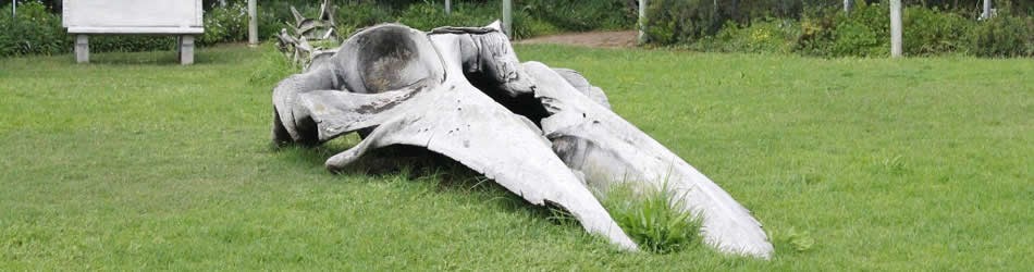
The upper-level of the Shell Museum boasts a collection of beautiful shells from all over the world! On this level there is also a “whale and dolphin exhibit”
This Great White Shark was caught by C. van Aswegen & J. Eksteen in 1981. It weighed 476 kg.
On the lower level the “touch tank” and aquarium enables visitors and school groups to actively learn about sea life and the creatures along South Africa’s shoreline. A “man and mollusc” exhibition portrays the history of the use of shells by man.
The Post Office Tree
In 1500 Pedro de Ataide, Commander of one of Cabral’s ships, on his return journey from the east, left a letter of importance in a shoe or iron pot under or near a large tree.
In 1501 this letter was found by Joao da Nova, commander of the third East India fleet en route to India. In this way the first Post Office in South Africa was founded. The large tree, a Milkwood (Sideroxylon inerme) has been declared a national monument and is generally known as the Post Office Tree.
The local post office has organised a wonderful way of communicating with the loved ones back home. The post box at the Old Post Office Tree can be used to post postcards and letters. A special frank is used on all outgoing mail to commemorate the fact that South Africa’s first post office was this tree! The reason for the boot-shaped letterbox is that it is presumed that the first letters were left at this old tree from the 1500’s in a sailor’s boot!
In the letter that da Nova received was a timely warning of problems near Calcutta and he was so grateful for this that he erected a small stone hermitage to be used for religious purposes. This was the first religious building in South Africa. The cross stands where it is thought the chapel or hermitage was built.
The Spring
Dias named the fresh-water spring "Aguada de São Bras" (watering place of St Blaize).
In 1512, Gaspar Correa, described it as flowing over a rocky verge into a small dam. The spring still flows today.
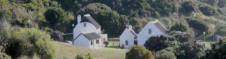
Munrohoek Cottages
The first building was built around 1830 by Alexander Munro from Scotland for £25. He operated a canteen on the premises where unruly seamen met. His son got the first permit to catch whales on the beach below. The front house is one of Mossel Bay’s national monuments. These buildings are, however, not open to the public.
Malay Graves
This site was discovered in 1968, not far from the Post Office Tree. Records show that a piece of land had been granted more than 100 years before as burial ground for Muslims.
It is believed that one of the graves is that of an important Moslem who was buried here in the 19th Century after dying on board a ship at sea. The graves face Mecca.
Map and Directions to Bartholomeu Dias Museum
GPS: 34° 10' 47.56" S / 22° 8' 30.18" E
From Cape Town
- From the N2 at exit 387 continue straight into Mossel Bay on the R102
- Bear left at the Marsh Street exit and turn right over the bridge at the traffic lights
- After 800m turn left into Kerk Street and continue to the sign "Welcome to the Dias Museum complex".
From George
- From the N2 take exit 393 "Mosselbaai" and turn left at the end of the ramp
- At the traffic lights turn right
- After 5.1 km bear left at the sign "Marshstraat" and then turn left towards the CBD
- After about 700m turn left into Kerk Street and continue to the sign "Welcome to the Dias Museum complex".